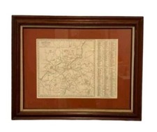
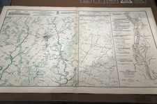
1920 Willow Township Iowa Plat Map, Crawford County Original 15x12
This original 1920 plat map of Willow Township, Crawford County, Iowa is a vintage paper collectible ideal for local history research, genealogy, or antique map displays. The map measures approximately 15 x 12 inches (check the listing for details). Condition is not specified; check the listing for details on wear, marks, or any restoration. Free shipping is included, and the item will be packaged to help protect it during transit. Review the listing photos and description to confirm the exact item, condition, and any included documentation.


| Location | Carefree US |
| Shipping | Free shipping (check listing for details) |
| Seller |
selsa84
100.0% positive · 6008 feedback
|
| Listing | FixedPrice · Active |
| Start time | 2025-12-10T13:23:58.000Z |
| Date Range | 1920-1929 |
| Type | Map |
| US State | AR, IA, KS, LA, MO, NE, Iowa |
| Format | Atlas Map |
| Printing Technique | Lithography |
| Year | 1920 |
| Original/Reproduction | Antique Original |
| Cartographer/Publisher | G.W. Anderson, Des Moines Iowa |
| City | WILLOW |
| Country/Region | United States of America |
ORIGINAL 1920 ANTIQUE COLOR PLAT MAP OF WILLOW TOWNSHIP IN CRAWFORD COUNTY IOWADATE-1920, NOT ON MAPPUBLISHED BY-G.W. ANDERSON, DES MOINES IOWASOURCE- ATLAS OF CRAWFORD COUNTY IOWA-1920ORIGINAL 1920 PLAT MAP OF WILLOW TOWNSHIPS IN CRAWFORD COUNTY IOWA. MAP SHOWS PROPERTY OWNERS NAMES ON EACH PLAT, PLAT NUMBERS, EARLY ROAD SYSTEMS, EXISTING RAILWAY ROUTES AND WATERWAYS. ALSO SHOWN ARE SCHOOL LOCATIONS AND HOUSES.MEASURES- 15 X 12 INCHESGOOD CONDITION, DISCOLORATION AND TEXT ON REVERSE