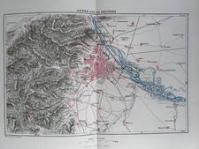
1911 Antique Map of Metz, Lorraine/Lothringen France Germany
This 1911 antique map features Metz in the Lorraine (Lothringen) region on the France–Germany border area. The map measures approximately 6 x 4 inches (15 x 10 cm) and is listed in good condition; check the listing for details on any age-related wear. It is suitable for collectors of historical cartography, regional European history, or antique paper items. Free shipping is included; check the listing for details on handling time, carrier, and delivery estimates.


| Location | Montreal CA |
| Shipping | Free shipping (check listing for details) |
| Seller |
montrealmaps
100.0% positive · 7883 feedback
|
| Listing | FixedPrice · Active |
| Start time | 2025-12-05T01:14:39.000Z |
| Materials sourced from | Germany |
| Publication Year | 1911 |
| Type | City Map |
| Year | 1911 |
| Country/Region | Germany, France |
| State | Lothringen |
| Region | Germany |
| Topic | Antiques |
| MAP SIZE | 6" x 4" (15 x 10 cm). |
| Maker | Baedeker |
| City | METZ |
| Date Range | 1910-1919 |
| Country of Origin | Germany |
-------------------------------------------------------------US buyers: this item is exempt from tariffs (HTS CODE: 4905.20.00.00)ORIGIN OF THE MAP: "The Rhine", 17th edition, published in Leipzig, Germany by Karl Baedeker. DATE OF ISSUE: 1911. SIZE: The sheet measures: 6" x 4" (15 x 10 cm).Most of maps we sell come from ancient atlases that were damaged and beyond repair. The maps have often a canvas or paper binding tape mounted on back along the centerfold. If you have ANY PROBLEM with the purchase, it is essential you CONTACT US BEFORE LEAVING FEEDBACK TO GIVE US THE CHANCE TO RESOLVE IT. SHIPPED FROM CANADA in secure tubes or bubble mailers. PLEASE NOTE, THAT THE SHIPPING FROM QUEBEC TO THE U.S. TAKES 10 DAYS / WORLD 18 DAYS. WE COMBINE SHIPPING COST FOR MULTIPLE ITEMS: THE POSTAGE FEE IS CHARGED FOR THE FIRST ITEM ONLY.