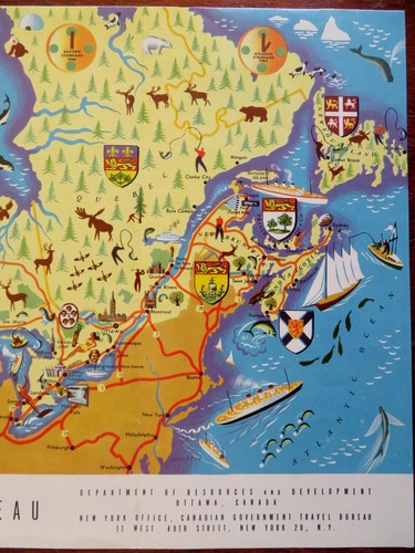
Canada National Parks Tourism Recreation 1951 cartoon pictorial souvenir map
Check the listing for details.


| Location | Dover, New Hampshire US |
| Shipping | USD 6.95 · Flat |
| Seller |
oldmapsoldbooks
100% positive · 12588 feedback
|
| Listing | FixedPriceItem · Active |
| Start time | 2023-03-02T19:49:59.000Z |
| End time | 2025-01-02T19:49:59.000Z |
| Time left | P2DT3H47M3S |
| Return shipping will be paid by | Buyer |
| All returns accepted | Returns Accepted |
| Item must be returned within | 30 Days |
| Refund will be given as | Money Back |
Canada National Parks Tourism Recreation 1951 cartoon pictorial souvenir map (Old Maps, 20th Century Maps, Canada, Travel, Tourism, National Park, Tourism, Recreations, Cartoon Pictorial Map). Canada. Published 1951, Ottawa, Canada by Edmond Cloutier. Folding cartoon pictorial travel map, printed on both sides of the sheet. Text in English. Map is old and shows some signs of handling and time. Sheet is not new or in "new" condition. The map could readily be framed for display if desired. Tourist map issued as a guide to highlight this company's Manhattan hotels. Tourist information & advertising on reverse. Paper gently age worn, slight rubbing, remains overall clean and attractive as an ephemeral survival. Map displays a pleasing and unique age patina and overall is in nice antiquarian condition, any age flaws easy to overlook or forgive. Please review photos for more detail and our best attempt to convey how this ephemeral cartographic item survives. Original fold lines as issued. Map measures c. 9" H x 18 1/4" W. [B8551].