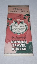
1936 CONOCO OIL Road Map NORTH DAKOTA Minot Fargo Bismarck Jamestown Devils Lake
Check the listing for details.


| Location | Lake Worth, Florida US |
| Shipping | Free shipping (check listing for details) |
| Seller |
new_world_maps
100.0% positive · 23233 feedback
|
| Listing | FixedPrice · Active |
| Restocking Fee | No |
| Return shipping will be paid by | Seller |
| All returns accepted | Returns Accepted |
| Item must be returned within | 30 Days |
| Refund will be given as | Money Back |
| Brand | Conoco |
| Type of Advertising | Road Map |
| Date of Creation | 1936 |
| Original/Reproduction | Original |
| Country/Region of Manufacture | United States |
| Industry | Gas & Oil |
| Region or Country | United States |
| US_by_Areas | North Dakota |
Vintage fold-out 1936 Conoco road map of North Dakota, printed more than 85 years ago. The map opens to 18" x 24" and has great detail on old highway alignments and route numbers, with cartography by H.M. Gousha. It also shows road surfaces and identifies roads that are "under construction or impassable." On the reverse side there are inset plans of Jamestown, Minot, Fargo, Bismarck, Grand Forks, the Devils Lake Region, and the International Peace Garden. This map was distributed by the Continental Oil Company of Denver in 1936, and it is dated by the code number in the lower margin: 3-J. Population data is from the 1930 census. Little triangles on the map locate Conoco service stations in the state. Condition: The map is in very good condition, bright and clean, with no rips, tears, or writing. Please see the scans and feel free to ask any questions. Buy with confidence! We are always happy to combine shipping on the purchase of multiple items — just make sure to pay for everything at one time, not individually. Powered by SixBit's eCommerce Solution